People involved

Patrick Hogan
Spatial analysis of catchment evapo-transpiration
Rasmiaditya Silasari
Hetrogeneity and scaling of runoff processes
Borbála Széles
Linking hydrological process patterns
Mariette Vrugendhil
Spatial and temporal variability in soil moisture from active microwave observations
Selected publications
Silasari, R., Parajka, J., Ressl, C., Strauss, P. and Blöschl, G. (2017) Potential of time-lapse photography for identifying saturation area dynamics on agricultural hillslopes. Hydrological Processes, (in press).
Vreugdenhil, M., Dorigo, W. A., Wagner, W., de Jeu, R. A., Hahn, S. and van Marle, M. J. (2016) Analyzing the Vegetation Parameterization in the TU-Wien ASCAT Soil Moisture Retrieval. IEEE Transactions on Geoscience and Remote Sensing, 54, 3513–3531.
Vreugdenhil, M., Hahn, S., Melzer, T., Bauer-Marschallinger, B., Reimer, C., Dorigo, W. A. and Wagner, W. (2016) Assessing Vegetation Dynamics Over Mainland Australia With Metop ASCAT. IEEE Journal of Selected Topics in Applied Earth Observations and Remote Sensing, 99, 1-9.
Research supervisors
Prof. Wolfgang Wagner
Prof. Günter Blöschl
Collaborators
Dr. Bernhard Höfle, University of Heidelberg, Germany
Prof. Albert I.J.M. Van Dijk, Australia National University
Prof. Dagnachew Legesse, Addis Ababa University, Ethiopia
Earth Observation Data Centre for Water Resources Monitoring, TU Wien
Research › Land Surface Processes
Processes at the land surface control climate dynamics and catchment runoff. This group develops novel methods for analysing remote sensing data along with fieldwork and modelling to understand these processes.
Land surface modelling
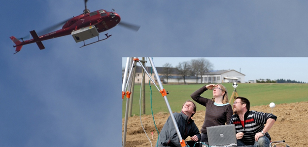
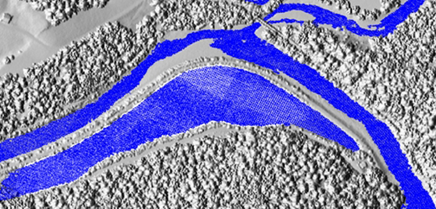
Airborne laser scanning offers great potential to provide detailed information on the land surface. Michael Vetter has developed a novel approach which analysis the entire set of laser reflections from the surface to build up a complete 3-D image of the vegetation structure and the land surface (see Research highlight). Such highly accurate terrain models improve water resource analyses by providing data for local runoff analysis, mapping of ephemeral streams, detecting soil accumulation and erosion, monitoring water resource structures, and estimating hydraulic roughness (a crucial parameter in hydrodynamic modelling, see Modelling).
Eleni Yeshaneh is combining different data sources to estimate actual land cover and its evolution over recent decades. Centred around issues of land degradation in Ethiopia, her research provides a basis for understanding the impacts of land management policies and soil and water conservation strategies (see Water resource management).
Soil moisture and scale
To understand more about the potential of remotely sensed soil moisture at varying scales Marcela Doubkova explores spaceborne radar data. Her interest focuses around determining how accurate these data are. By comparing three different data sets (satellite data, ground measurements, hydrological models) at the same places in space and time (in Australia) she was able to estimate how accurately each data set describes soil moisture. This information is essential when soil moisture data are to be used in hydrological and climate prediction models.
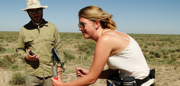
A more detailed study of the accuracy of this type of satellite soil moisture data is performed by Mariette Vruegdenhil. The satellite data typically covers a large grid square. To explore how the data can be downscaled, she is measuring soil moisture in the Hydrological Open Air Laboratory and comparing it to remotely sensed data. Her work will provide valuable ideas and approaches for applying remotely sensed information to the scale frequently needed for small and medium sized catchments and for understanding exactly which land surface characteristics are reflected in the satellite data.
Additional research in the Hydrological Open Air Laboratory on small scale process studies of evaporation and runoff complement the other, larger scale research in this cluster. For example, Patrick Hogan is exploring feedbacks between the atmosphere, soil moisture and vegetation. Using the eddy-correlation method to measure humidity and wind he is able to identify how the spatial patterns of the land surface characteristics affect evaporation and the local atmosphere.